The PH Weather and Earthquakes app is your ultimate resource for real-time weather and earthquake information in the Philippines. Powered by data from PAGASA's Project NOAH and PHIVOLCS, it provides comprehensive coverage of weather forecasts, earthquakes, tsunamis, and volcanic activity. Beyond Philippine-specific data, the app also includes a global earthquake list sourced from the U.S.G.S., offering a broader perspective on seismic activity worldwide. Its functionality extends to various monitoring tools, such as Doppler radar, and sensors providing real-time readings of stream gauge, rain gauge, tide level, and weather station data. Interactive hazard maps for floods, landslides, and storm surges help users assess and plan for potential risks. The app also includes practical emergency tools—a flashlight, compass, and more—enhancing preparedness in critical situations. Further enhancing its utility are features like weekly and hourly weather forecasts, a moon phase calendar, and integration with PHIVOLCS's Fault Finder and LAVA systems. For feature requests or feedback, visit their official Facebook page.
Features of PH Weather and Earthquakes:
- Weather Updates: Access real-time weather updates from PAGASA's Project NOAH, including detailed 4-hour and 4-day forecasts. Stay informed about cyclones, typhoons, hurricanes, and other severe weather events.
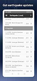
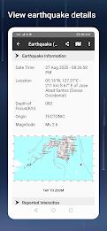
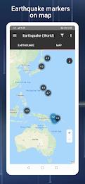
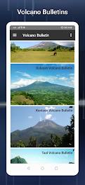
- Earthquake, Tsunami, and Volcanic Activity Updates: Receive timely alerts and crucial information regarding earthquakes, tsunamis, and volcanic activity directly from PHIVOLCS, ensuring your safety during natural disasters.
- Monitoring Tools: Utilize a suite of monitoring tools, including Doppler radar and various sensors (stream gauge, rain gauge, tide level, weather station), providing comprehensive data on current weather conditions.
- Hazard Maps: View detailed hazard maps illustrating areas at risk from floods, landslides, and storm surges, enabling informed decision-making and effective emergency planning.
- Emergency Tools: Be prepared with integrated emergency tools such as a flashlight, strobe light, siren, and compass, providing essential functionality during emergencies.
- Additional Features: Explore supplementary features, including MT Satellite imagery and videos, Ovitrap (dengue) reports, government Twitter updates, a critical facilities list, and a moon phase calendar.
Conclusion:
The PH Weather and Earthquakes app is an indispensable tool for staying informed and prepared in the Philippines. Its comprehensive features—from real-time weather and seismic alerts to interactive hazard maps and emergency tools—provide a robust solution for weather awareness and disaster preparedness. Download the app today and enhance your safety and readiness in the face of unpredictable weather and natural calamities.
Tags : Lifestyle